 |
||
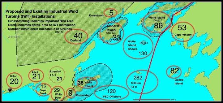
Uncalculated Cumulative Effects The situation on Amherst does not exist in isolation and cannot be considered in isolation. The map below indicates proposed and existing turbine installations in the area immediately surrounding Amherst Island. The red circles indicate the proposed and existing turbine installations with the proposed number of turbines indicated in within the circle. Due to the high level of “secrecy” maintained by the various corporations, these numbers are estimates. The cross-hatching indicates five Ontario Important Bird Areas, there are more in the United States. Amherst Island is located in the center of the map, towards the top with 33 turbines listed. (This is the number of turbines required if Algonquin Power follows through on their plan to install 2.3 Mw turbines for a 75Mw development.) Looking at the map above - where will the birds fly?
|
The cumulative effect of the turbines proposed by various corporations for the eastern end of Lake Ontario, must be considered. The approximate 450 proposed and installed land-based turbines would be sited along approximately 50 km of ecologically fragile shore-line between Point Petrie in Prince Edward County and Wolfe Island. There are an additional 530 IWT proposed for installation in the water. The 86 turbines on Wolfe Island are responsible for the highest bird / turbine kill ratio in Canada, and are second only to Altamont Pass in the US for highest bird / turbine kill ratio in North America. The cumulative effect of an additional 850 turbines in such a biologically significant area can only serve to echo and magnify the Wolfe Island disaster. |
|